
| Abbreviation | ROAASPCO |
| WDID | 3802071 |
| Well Permit | |
| USGS Station ID | 09073400 |
| Cooperator ID | 09073400 |
| Drainage Area | 106 |
| Contributing Area | |
| Gage Datum |
| Division | 5 |
| Water District | 38 |
| County | PITKIN |
| State | CO |
| Water Source | ROARING FORK RIVER [00174812] @ Stream Mile: 46.90 |
| Hydrologic Unit Code | 14010004 |
| UTM X | 344353.9 |
| UTM Y | 4338296.9 |
| Latitude | 39.179995 |
| Longitude | -106.801993 |
| Location Accuracy | User supplied |
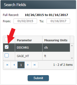
Observations - Original Measured Values
| From |
|
To |
|
Title
Y Axis Min
Y Axis Max
No Results Yet
Try performing a new search.
Graph Disabled
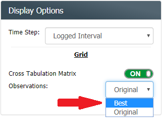
Analysis - Best Available Data
| From | To |
Water Year
Irrigation Year
Calendar Year
| From |
|
To |
|
Title
Y Axis Min
Y Axis Max
No Results Yet
Try performing a new search.
No Peak Streamflow data for this station.
No Results Yet
Try performing a new search.
No measurement data for this station.
No Results Yet
Try performing a search.
| GAGE | .00 | .01 | .02 | .03 | .04 | .05 | .06 | .07 | .08 | .09 | DIFF |
|---|
Loading rating table...
The graph shows both the base rating and the current shift adjusted rating.